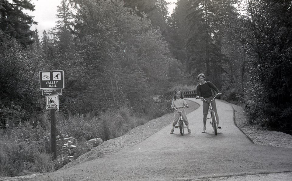
No matter the time of year, there are sure to be people out on the Valley Trail, whether biking, rollerblading, skateboarding, walking, jogging, or skiing. The popular multi-use trail system runs throughout Whistler and, for decades, has been used by many for both practical and recreational purposes.
The origins of Whistler’s Valley Trail go back to 1976, just one year after the Resort Municipality of Whistler (RMOW) was formed. A rec report prepared by representatives of the Whistler Developers Association, the Alta Lake Ratepayers Association, the Advisory Planning Commission, and the RMOW looked at existing recreation infrastructure within the municipality and made recommendations for future recreation development. These recommendations included “a main valley trail of a minimum 12-foot-wide, dust-proof surface” connecting the existing recreational and community facilities and residential developments for cyclists and pedestrians.
This call for a trail system through the valley was echoed four years later in the 1980 Recreation Committee Report and by the Whistler Outdoor Recreation Master Plan Study prepared for the RMOW by Professional Environmental Recreation Consultants Ltd in 1980, often referred to as the PERC report.
One reason the PERC report prioritized the development of a bikeway was to make travel safer within Whistler. According to the report, “the [then] current system of bicycling on Highway 99 through Whistler is unsafe due to the heavy traffic and especially due to the number of logging and other heavy vehicles using the highway.”
To address this issue, the PERC report proposed building about 13 kilometres of paved bikeway over five years to create a north/south spine that began at the RV campground at the south end and ended in Alpine Meadows to the north. Along the way, the bikeway would link subdivisions and other developments, including Whistler Village. The master plan also included plans for a Lost Lake Loop and a Fitzsimmons Creek Loop that could be added to the trail system, as well as an extension of the spine north to Emerald Estates along Green Lake.
Over the next four years, the Advisory Parks and Recreation Commission (ARPC), guided by its chair Trevor Roote, led public consultation meetings, passed a referendum to fund its master plan, and negotiated rights-of-way throughout the valley for the Valley Trail. By 1982, the trail was paved from the village to Alta Vista and from the River of Golden Dreams to Rainbow Drive. According to Roote, the trail “immediately became a popular commuting route, particularly with school children who no longer had to ride their bikes to school along Highway 99 playing dodge’m with logging trucks.” In 1983, the trail was paved from the village to Whistler Cay and from Rainbow Drive to Meadow Park.
Many elements of the trail system described in the PERC report are part of the Valley Trail today. The ARPC did incorporate the trail right-of-way into the negotiation of sewer rights-of-way, and the general location of the trail matched much of what the PERC report proposed. The next five-year plan of the ARPC (1985 to 1989) included the expansion of the Valley Trail out towards Emerald Estates. The physical design of the trail, however, is not quite as the PERC report envisioned.
While most Valley Trail users are accustomed to a mix of walkers, cyclists, skateboarders and more, all keeping to the right of the yellow line except to pass (and then using their bell or calling out to alert those they’re passing), the PERC report proposed a six-foot, two-way paved bikeway with a separate-but-adjacent three-foot gravel pedestrian trail.
The importance to the community of developing recreation, and in particular the Valley Trail, was recognized quite early on. For his work as the chair of the ARPC, Roote was named Citizen of the Year in 1981, and was awarded the Freedom of the Municipality in 1984. Since then, the Valley Trail has continued to expand throughout Whistler, and continues to be a popular commuting and recreational route for residents and visitors alike.


