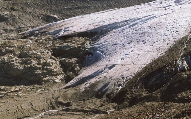
Contrary to popular perception, the hot, dry summer did not generate record recession of the two local glaciers we monitor.
This year, the team visited Wedgemount on September 6, ascending the approach trail to the din of heavy equipment working the opposite side of the creek in the construction of an IPP run-of-the-river power project.
Below 1,400-metres elevation the creek is outside of the provincial park and with a powerhouse below that at 600 to 700 metres elevation, the project has a hefty 700-plus metre head to work with for very efficient power generation — an investor's dream.
Well, as long as the glacier is actively there, above the operation, it is a sound project. Wedgemount Glacier, however, is shrinking both in areal extent and in thickness.
The bare-ice to snow-covered ice equilibrium line was at the highest elevation that I had ever witnessed, over 40 years of observations, at or near the conclusion of the melt season. It was above the upper icefall at about the 2,550-metre contour.
Normally, the equilibrium line lies below the upper ice fall, around 2,100 to 2,200 metres, ensuring the glacier will survive despite the global trend to gradually warming seasonal climates.
This past year, the terminus of the glacier receded 25.6 metres, about double the long-term average but not a record amount. The overall amount of thinning of the surface was not measured this year, but it was obviously a lot.
The ice cave seen at the terminus in the past few years has disappeared due to the thinning surface and the new emerging ponds at the edge of the glacier are expanding.
Like last year, the first weekend of September was, again, a busy time for campers at Wedgemount. Tents at the lakeside campground numbered 20 or more, and another eight were pitched near the cabin, where four people also bunked out. Fortunately, the outhouses were functional at both sites!
On Sunday morning, Sept. 7, our descent on the trail encountered 61 day-trippers on their way up.
Reaching the new 20-stall parking lot, the inadequacies of the IPP project were glaringly obvious — another 47 cars were parked outside of it strung along the access road. Coupled with a deteriorating trail, it is apparent that the Parks Service was a poor bargainer with the hydro-electric developers who closed the old, larger and more aesthetic parking lot and built a new sub-standard replacement trail.
There it meets the trail established in the early 1970s, now in need of much repair, the product of the wear and tear by ever-increasing traffic.
The attraction is a stark alpine lake and adjacent shrivelling glacier in a beautiful setting, and the trail is the only easy access to the two highest peaks in the park. Mountaineers will always use it regardless of its condition, and who knows, maybe the glacier will grow — again.
Two days later, it was a vastly different scene in our annual visit to Overlord Glacier. There was only one other mid-week visitor to Russet Lake, and darn few hikers were on the Musical Bumps and Singing Pass trails.
The atmospheric temperatures had now swung from sweltering hot to breezy and very chilly. Snow banks, which normally abound around the lake basin were gone, although the equilibrium line on the glacier was near the usual elevation at about 2,150 metres elevation.
Nonetheless, the terminus of the glacier had receded about 18.5 metres from its 2013 position, although ice lenses buried by rock rubble were lying in front of exposed ice to add complications to the measurements.
This is an average of two values as explained in the following description. The glacier has had a two-tongued projection of its glacier margin. One with insulating rock rubble on its surface retards the recession, and the other is without protective cover that has now receded into obscurity, 24.2 metres this year. The rubble-covered snout, on the other hand, had receded about 12.8 metres, subject to the vagaries of ice not seen under the overlying cover of rocky debris.
This year's Wedgemount surveys were assisted by Dave and Graham Lyon, Robbie Tupper, Erich and Eileen Hinze, and Marilyn Cram, while Marilyn was the only trooper to help with the Overlord survey.
Regretfully, the BCIT Survey Dept. did not show up this year to conduct measurements on the thinning of the glacier's surface.


