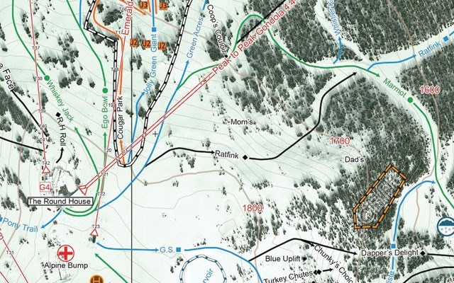
Both the map-challenged and the map-savvy can give thanks to Alex Hordal, whose digital, detailed, accurate renditions can make it easier to navigate and pinpoint locations on the vast trails and terrain of Whistler Blackcomb (WB).
"One guy said it stopped him from going off a cliff," said Hordal, whose maps begin with a base image that is layered with terrain details and infrastructures right down to the lift tower numbers.
"A lot of people have told me the maps are very handy — they just pull out the map and it shows them exactly where they are. They hit the button and know where they are within two to five metres."
His maps of Whistler and Blackcomb mountains are used by Whistler Blackcomb for patrol dispatch, and by several mountain user groups. He's also created a bike park map and is working on a Spearhead Traverse map, which he hopes to have ready within a few months. (Hordal's Whistler Mountain Mapping Initiative [WMMI] has no affiliation with WB.)
"The thing about my maps is because of the coordinates embedded in the image, you know exactly where you are. Not only that, you don't need a data connection on your phone, it's all based on GPS as long as your phone has a GPS chip in it, you should be able to pinpoint your location."
Hordal's maps of Whistler and Blackcomb are created facing downward in the direction of travel.
"When you actually have the map out, everything that's downhill from you is as it is, which helps a lot in terms of navigation."
Hordal started WMMI a few years ago as a ski patroller trying to navigate Whistler Mountain.
"I had been a ski instructor on Blackcomb and knew it really well," he said. But when he was assigned to patrol on Whistler, it was an adjustment.
"I was so familiar with Blackcomb, so here I am on Whistler trying to figure out where I'm going. They have these maps that are black and white and basically the same maps that the public gets and they overlay names on them but it's fairly ambiguous," Hordal said, adding that the information overlaid on the map is not detailed enough to differentiate, for example, between a dip in the terrain or a group of trees.
"That's where it all started, trying to create something less ambiguous," he said.
"What I'm trying to do is get accurate information to people. There's millions of people who come and ski WB and often having no idea where they are, they frequently become lost," he said.
"The more people who know about the map's existence, at least it gives them the opportunity to see whether it's something that could potentially help them out."
Hordal, who holds a degree in geography, said he's naturally drawn to this discipline and the digital configuring that's required.
Hordal starts with a base image, or an Orthophoto, which is purchased from either the province of B.C. or the municipality. Hordal's imagery for these maps is from detailed 2009 security images that were taken before the 2010 Olympics.
Hordal then geo-references the image, which allows him to add layers of topographical information exactly where it should be. The third and final layer on the map is identifying information, such as trail names.
"There's information that you get from all kinds of sources, so you're going to have names that patrollers use. And names that groomers use — they have all kinds of names that only they refer to. And then you have racing. A bit of our information comes from the Olympics where they had all kinds of specific names for portions of Olympic ski runs."
What it creates is such detailed information that can assist not only a first-time visitor, but to send help to the exact location.
"I think it's helped a lot of people, this is the feedback I've gotten. And that's important. I think it's made some people more efficient at responding to accidents," Hordal said.
As the backcountry explodes in popularity and the funding for the first Spearhead Hut underway, Hordal said this type of mapping is on an entirely different scale as the area is so much larger and users shouldn't rely solely on a digital map.
"It's always a good idea to have a paper map. This is going to be our first actual printed map, then we have to look at sponsorship for printing and look at printing sizes, there's just a whole bunch of different issues that weren't really present in our other maps," he said.
"More people are going to get into the backcountry and those huts are a great way of doing it safely," he said. "I'd really like to add the information from the Spearhead Huts committee as a kind of pro-bono thing to try to get the word out about their project as well because there's a lot of people who belong to that project who have a lot of experience in what I'm doing in the area, specifically mapping. It could be a really good mutual collaboration."
Hordal hopes to have the Spearhead Traverse map completed within a few months. From there, he said he may look at mapping Pemberton Valley, or snowmobile routes. And he often gets requests for printed maps for people to hang on the wall of their ski cabin.
"It's always evolving. I spend probably two hours a night looking over maps and looking at imagery and adjusting things.
"I can only imagine what it would be like travelling around the world and making maps for ski resorts," he said with a laugh.
For information and maps, go to wmmi.ca or check the Facebook page Whistler Mountain Mapping Initiative.


