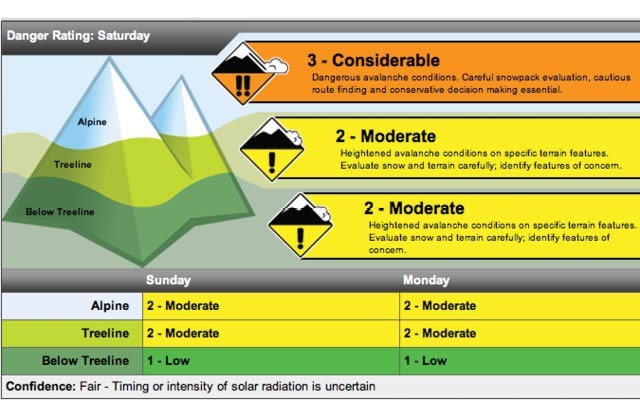
It looks like the most dangerous avalanche conditions in the Sea to Sky corridor have passed with Whistler Blackcomb and the Canadian Avalanche Centre (CAC) lowering the avalanche danger rating for the area. The CAC has rated the danger for the next few days between Considerable and Low.
The CAC rating for Sunday drops to between Moderate and Low and the WB rating shows the same adjustment.
While the danger rating has been adjusted down, WB continues to warn that the warm temperatures will add tension over the deep, weak layers in the snowpack.
The WB report for today (Jan. 18) suggests: “Be cautious of the potential for deep slab avalanches in steep lee areas. Solar-triggered avalanches are also a concern.”
The drop in the danger-rating comes following a high of four degrees Celsius on Friday, Jan. 17 and a noon temperature today of two.
The forecast from Environment Canada is calling for a mixture of sun and cloud for the next few days with highs between three and six degrees while overnight lows are predicted to fall to minus four or five through to Tuesday. The overnight low on Wednesday is predicted to dip down to zero.
Around B.C. this weekend a number of Avalanche Awareness events are taking place. Rangers with BC Parks were at Red Heather Hut in Garibaldi Provincial Park today for a free avalanche awareness event showing avalanche clues in snowpack layers to anyone at the hut for the event. Avalanche transceiver demonstrations were held along with displays of the latest innovations in avalanche equipment. The avalanche awareness event picks up again tomorrow (Jan. 19) at the hut between 11 a.m. and 2 p.m.
-Update by John French
Original report from Friday, Jan. 17
The Sea to Sky region, including Whistler, Squamish and Pemberton, has been included in a special public avalanche warning issued by the Canadian Avalanche Centre on Friday, Jan. 17.
This weekend's sun and warm, possibly record-breaking temperatures, will destabilize a complex and highly variable snowpack leading to surface slides, said CAC Public Avalanche Warning Service Manager Karl Klassen in a release.
The regions impacted include the Northwest Inland, South Coast Inland, Sea to Sky, North Rockies, Cariboos, North Columbia, South Columbia, Purcells, Kootenay-Boundary, Lizard Range, and South Rockies.
This warning applies to recreational backcountry users and runs from Friday, Jan. 17 to Monday, Jan. 20.
In many areas there are also weak layers near the base and at mid‐level of the snowpack, said the release.
“In addition to smaller surface slides during the coming warm spell, we have the potential for very large natural and human‐triggered avalanches failing deep in the snowpack throughout the weekend,” says Klassen.
“We’re concerned about ‘blue sky syndrome’ this weekend. It’s common to have a false sense of security in good weather, and this weekend that could lead to underestimating the hazard.”
The CAC recommends recreational backcountry users with little or no avalanche training or experience avoid avalanche terrain, or undertake activities in which avalanche risk is managed by professionals.
Experienced backcountry recreationists are urged to travel on simple terrain such as small, low angle, well‐supported features with no large, steep slopes or cornices above.
When temperatures are warmest and especially if the sun is out, all avalanche terrain should be avoided, including valley bottom runout zones.
Every person in a backcountry party is recommended to take an avalanche transceiver, probe and shovel and everyone should have some training in recognizing avalanche terrain and applying safe backcountry travel techniques.
For more information, check the current avalanche forecast for your area at avalanche.ca/cac and click on the “bulletins” tab. The forecasters’ blog can be found at blogs.avalanche.ca.


