
There's a place in southern Peru called the Nazca Plain. Classified as a coastal desert, it is one of the driest places on Earth, getting less than 2.5 centimetres of rain a year. Blame it on the Humboldt current—a cold, low-salinity ocean stream extending from southern Chile along the western coast of South America. During its journey, the equatorial-flowing waters rob the coastline of moisture, rendering a parched coastal interior resembling a Martian-like landscape while providing enriched and plankton-laden waters for marine life. Erosion and change are minimal as there is an absence of degrading forces such as wind and water.
The Mystery
As a result of special environmental conditions. a perfect setting was created for preserving gigantic line excavations created by a civilization that lived here between 200 BC and 600 AD. The Nazca Lines weren't even known to exist until the airplane was invented, giving an advantaged aerial perspective from above. In the early 1930s, as pilots flew over the seldom-traversed, barren terrain while surveying for water, they noticed strange geoglyphs of enormous proportions.
Today, the lines and geoglyphs of Nazca and Palpa are designated a UNESCO world heritage site (1994), even though an enigma remains regarding their origin and purpose. One thing is for certain: The gigantic lines and geometric designs were created with a precision that defied conventional tools and knowledge of the day. It's for this reason that mysteries still surround the Nazca Plain. Why would an ancient people invest such a huge amount of time in creating these lines and figures?
There seems to be general agreement among historians, archaeologists, researchers and scientists that the Nazca lines were created by removing the top layer of darkened pampa stones and revealing the lighter coloured sand underneath. Essentially, the geoglyphs are formed by depressions in the soil that remain in their original state because there has been so little wind or water to erode the soil over time.
It's still not completely understood how these ancient people constructed lines and shapes with such precision while lacking an aerial perspective. From the ground, many of the forms are not easily discernible. Over the years, intense scientific investigation, as well as speculation, has added to the mystery, offering theories that range from ancient irrigation ditches to a UFO runway for extraterrestrial beings.
From Lima to Paracas
The best way to see the Nazca Lines is with a sightseeing small-plane excursion. Though a free viewing platform is accessible by car, line-of-sight is restricted and only a few figures can be seen from the station.
As a guest on the International Expeditions (www.ietravel.com) river cruise on the Peruvian Amazon, I chose the Nazca Lines as a pre-cruise tour, since it had been on my bucketlist for way too long. Lima Tours was the locally contracted operator and our guide Ronny Vizcarra was phenomenal—a true expert. We were originally on a morning flight, but due to encountering extensive traffic from Lima to Paracas, a journey of about three hours, we were running late. Ronny quickly arranged for our group to take the afternoon flight, ensuring we had reserved seats, while re-arranging lunch before our afternoon boarding.
After lunch in Paracas, we drove to the Nazca Lines where we flew with Aerodiana. The 90-minute overflight occurs in a 12-passenger Cessna Grand Caravan, a high-wing configuration most conducive to photography. The flyout altitude is about 2,700 metres with cruising from 600 to 1,100 metres while on site. First Officer Carranza narrated our tour in English, even humouring us by barking like a dog when we flew over the dog shape.
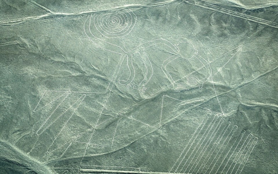
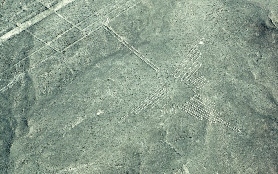
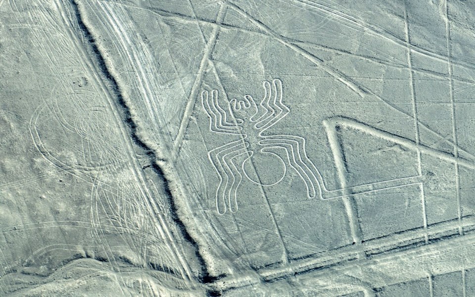
The figures come in two types: biomorphs and geoglyphs. The biomorphs are animal and plant forms, with some 70 grouped together in one area of the plain. Some of the more popular ones include a whale, astronaut, spider, hummingbird, monkey, dog, parrot, condor, and a pelican. Some archaeologists estimate they were constructed around 200 BC, almost 500 years before the geoglyphs.

Geoglyphs are geometric forms that include straight lines, triangles, spirals, circles and trapezoids. Enormous in size, there are about 900 geoglyphs. The longest straight-line measures 14.48 kilometres, (about nine miles).
If you take the flight excursion, book early, especially during holiday times. (Most flights depart full). As you'll be photographing from inside the plane windows, you will want to minimize reflection, which is worse in the afternoon. Best done by wearing a white or neutral-coloured top. And if you are prone to motion sickness, take medications beforehand, as the plane frequently banks right and left to give both sides of the plane equal viewings. Everyone has a window seat.


