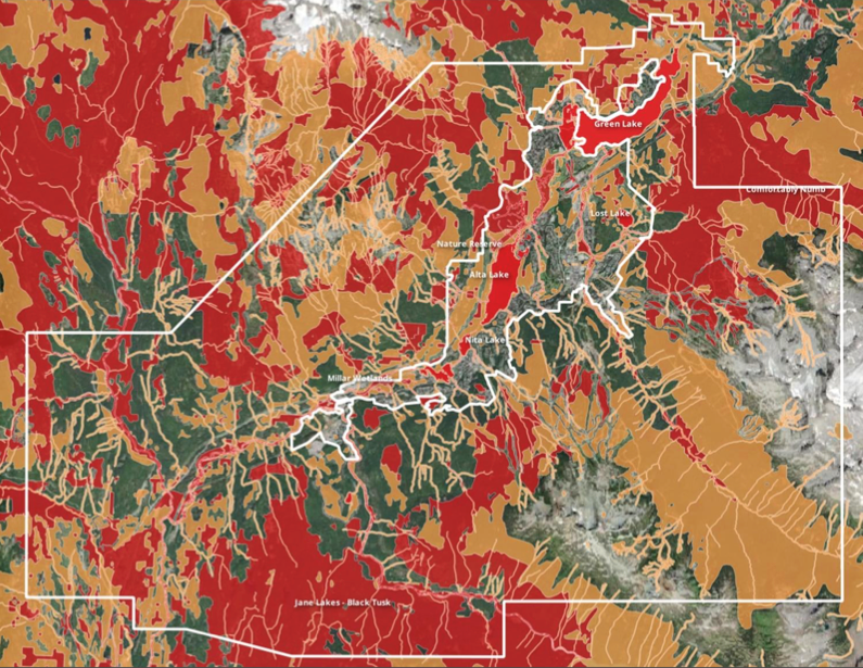
The Resort Municipality of Whistler (RMOW) has identified the community’s most important wildlife habitat in an update to a years-long project called “the most comprehensive and informative” series of ecological maps ever produced by the RMOW.
The Priority Habitat Framework (PHF) is a strategic document intended to guide land-use planning and conservancy efforts at municipal hall.
“This project is essentially a biodiversity conservation strategy for Whistler, a guide to help us protect critical spaces for Whistler’s most ecologically important species, to support local biodiversity, and so much more,” explained Tina Symko, RMOW environmental coordinator, in a Nov. 19 presentation to council.
The project builds on years of previous work that culminated, in 2018, with an initial priority habitat report that identified and defined Whistler’s priority habitat areas and ranked local wildlife species according to several factors. This most recent update makes refinements to the priority habitat list first developed in 2018, namely, adding ancient forests, those 400 years and older, to the old forest priority habitat type.
“These are globally significant ecosystems, and you can’t get much rarer than that from a local, provincial or global standpoint,” said Bob Brett, longtime local ecologist who was contracted by the RMOW to complete the habitat mapping and prioritization.
The project identified 20 different ecosystem-based and species-based habitats. The corresponding set of publicly available geographic information system maps include the RMOW’s first-ever species-based habitat maps for multiple species of local importance, including beavers, salmonid fish, Western toads, goshawks, mountain goats, and grizzly bears.
“Simply put, protecting key habitat for these key species means protecting habitat for many, many more,” Symko explained.
Initial implementation of the PHF, which began in fall 2023, involved scoring each priority habitat based on three main factors: rarity, connectivity, and importance to key local species. The updated framework only includes habitat that was scored as high or very high importance. Approximately 30 per cent of the 24,586 hectares within Whistler’s municipal boundaries has been identified as very high priority habitat, while roughly 19 per cent of the 2,550-ha. of developable area within Whistler has been deemed the same.
Councillor Cathy Jewett asked whether the PHF would address enforcement on issues such as off-leash dogs disturbing shorebird nesting habitat at Green Lake and unauthorized brush-cutting in designated riparian zones.
“That’s certainly the intention,” Symko said. “We’ll be looking at a range of protection measures, from fencing to policy and regulations. In terms of how we apply this, right now we’re literally getting the lay of the land with the mapping.”
The PHF includes several connectivity-focused maps, including recruitment and future forests; east and west mountainside greenbelts; and cross-valley greenbelts, which weren’t assigned a score as part of the PHF overview map, but are no less important to local biodiversity.
“These connectivity maps can help us look ahead to see how we might maintain key habitat connections across our community in the future,” Symko said.
A focus on connectivity emphasizes taking a long view of Whistler’s development, Brett said.
“The whole idea is placing within context anything we do on the landscape,” he explained, noting how development has impacted the area between the Nesters waste depot and Nicklaus North Golf Course over the years.
“That used to be a very big wildlife corridor, and now it’s much less valuable than it would have been 40 years ago. I’m not saying that was the right or wrong decision. All I’m saying is that right now, we have an opportunity going forward to make sure we don’t infill so much that we prevent [connections] from happening in the future.”
Over the next six months, RMOW staff plan to familiarize themselves with the updated mapping and share them with external partners. In the long term, the PHF will be used to assess the condition of specific habitat areas, particularly on Whistler’s developable land. This assessment will inform the development of a restoration strategy on habitat where it is required.
The updated maps can be viewed at whistler.ca/services/maps.


