
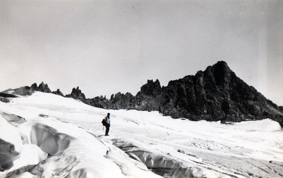
This September marks the 100th anniversary of the 1923 Neal Carter and Charles Townsend expedition. These two avid explorers climbed several of our local mountains, starting with Wedge Mountain and ending with the “most exciting” Diavolo Peak. It was a two-week journey from Sept. 9 to 20. Many of these climbs were recorded as first ascents, in which Carter and Townsend named some of the peaks, ridges, glaciers, and lakes they encountered.
During this expedition, the pair took photographs and detailed notes. A collection of these photographs was given by Carter to Myrtle Philip, who hosted them at Rainbow Lodge. They used the lodge as their starting-off point and rest stop in between destinations.
Though small, each image has detailed labels and notes on the back. Combined with Townsend’s comprehensive accounts in “The B.C. Mountaineer,” we can get a pretty good picture of their venture. Carter and Townsend traversed difficult, untracked terrain and changing conditions, but also witnessed spectacular views and were even treated to an eclipse.
It was not just for kicks that these two went out to explore the area. There was a strong purpose amongst mountaineers at the time to map the region and share what they had learned with others. Carter was a talented cartographer, and created topographical maps from this trip and several subsequent ones. His insight into the region assisted in the first official Garibaldi Park map in 1928.
However, these were not the only two that contributed to this major development. A group of Vancouver mountaineers formed the BC Mountaineering Club (BCMC) in 1907, and focused on exploring the Coast Mountains. As far as they knew, there were no records or maps of the mountains they set their sights on, and they assumed they were largely unexplored.
The mountaineering community in Vancouver started off small, consisting of both men and women, and grew over time. The BCMC welcomed newcomers through its summer camps, at which both Carter and Townsend joined in the early 1920s.
By this time, the BCMC had covered much of the area surrounding Garibaldi Lake. William Gray, president of the club in 1912, developed a sketch map that showed Black Tusk as the northernmost part of the district.
From years of exploring the Garibaldi region, the group was captivated by its natural environment and grew interested in its preservation. Logging and mining companies had establishments throughout the corridor, so the group campaigned to the provincial government to protect this area. In 1920, the Garibaldi district became a park and, before the decade was out, was designated as a Provincial Park.
The latest temporary exhibit at the Whistler Museum, Mapping the Mountains, takes a closer look at Carter and Townsend’s 1923 expedition and its cartographic results. Visit the Museum to learn more and see closeups of some photographs until Nov. 14.


