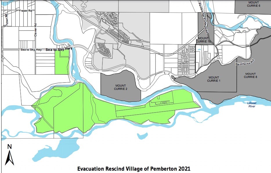
The Village of Pemberton (VOP) has rescinded its evacuation order for all of Pemberton.
As of late Tuesday morning, June 29, "the risk has decreased to the point that it is currently safe to re-occupy" the evacuated areas, officials said. Earlier, Emergency Management BC said water is still on the rise and is expected to peak around 4 a.m. Wednesday morning. However, a new forecast revised that information.
Officials are still asking the public to avoid camping near waterways and to stay clear of fast-flowing rivers and possibly unstable riverbanks.
On Monday, June 28, the VOP rescinded the evacuation order for Pioneer Junction, the Peaks, and some properties on Highway 99.
"This is not due to a reduced flood risk, but rather to emergency works conducted by the Village of Pemberton and PVDD [Pemberton Valley Dyking District] overnight," a VOP spokesperson said in an email.
The evacuation order for Airport Road, however, remained in place. The runway was closed as of 5 p.m. Monday.
Meanwhile, the Emergency Reception Centre at the Pemberton and District Community Centre (7390 Cottonwood St.) reopened Monday at 10 a.m. Anyone who needs assistance can go to the centre or call the Emergency Support Services Registration Line at 1-888-800-6493.
"The worst of the flood risk has definitely not passed," the spokesperson said.
An evacuation alert for parts of the Squamish-Lillooet Regional District's Area C, the Pemberton Valley, and Mount Currie issued on Saturday was updated to an evacuation order later that night amidst increasingly high water levels.
The order was put in effect at 8:30 p.m. on Saturday, June 27, "due to immediate danger to life safety caused by flooding in the Pemberton Valley," according to the SLRD's website. Residents must leave the area immediately.
Unusually high seasonal temperatures have led to snowmelt and, as a result, rapidly rising rivers throughout the area. With the heatwave expected to continue throughout the coming week, The BC River Forecast Centre has issued a Flood Watch. Groundwater saturation has already resulted in some surface flooding, according to the SLRD.
The evacuation order applied to the following properties:
- Street address numbers from 1830 to 2162 on Sea to Sky Hwy 99
- Street address numbers from 7294 to 7348 on Clover Road
- Street address numbers from 7912 to 8184 on Pemberton Meadows Road
- Street address numbers from 8035 to 8037 on Ryan Creek Road
Several maps available here outline the areas in further detail.
Residents in these areas were instructed to evacuate by heading north on Clover Road toward Sea to Sky Highway 99, south on Ryan Creek Road/Miller Bench FSR toward Pemberton Meadows Road, and south on Pemberton Meadows Road toward Sea to Sky Hwy 99.
Before evacuating, residents were told to shut off all gas and electrical appliances, other than refrigerators and freezers, close all windows and doors, and close—but not lock—gate latches. Evacuees needing assistance should call the provincial government's Emergency Support Services registration line at 1-888-800-6493.
Pemberton Valley trails flooding
The SLRD is also urging residents to avoid trails that are reportedly experiencing or at risk of flooding. Those trails include Bathtub, Live Like Lisa, the Valley Loop and the One Mile Lake area, including the boardwalk at One Mile Lake.
Officials are also directing British Columbians to refrain from camping near rivers or streams anywhere in the Pemberton area, at present or in the coming days. "These rivers reach their peak levels during the night. The area you go to sleep in, even if in a vehicle, may be flooded before you wake up," reads an emergency notice posted to the SLRD's Facebook page.
"Take extreme caution if you are on the trails or backcountry. The stream you cross on the way in may be a lot higher on the way out."
Big Sky Golf Club & Fescues Restaurant will be closed until further notice, as is Sunstone Golf Club and Bar and Grill.


